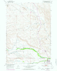
1951 Map of Fort Washakie
USGS Topo · Published 1979About this map
The Wind River Indian Reservation landscape is defined here by the confluence of vital water systems and early irrigation infrastructure. Near the settlement of Fort Washakie, the terrain transitions from the elevations of Bighorn Ridge and Sandstone Butte into fertile basins. The presence of the North Fork Ditch No 1 and North Fork Ditch No 2 alongside the North Fork Diversion Canal illustrates a sophisticated mid-century effort to manage the Wind River and its tributaries for agriculture. Local life in the early 1950s is anchored by the Countryman School within Countryman Basin, while nearby Landing Strips and oil infrastructure, including Oil Wells and Oil Tanks, indicate the dual importance of transportation and natural resource extraction in this corner of Fremont County.
Find a feature on this map
26 named features on this map. Tap any name to fly to it.
Don’t see what you’re looking for? This feature index may not catch every label — zoom into the map to look around manually.
Map Details
Editions of this 1951 Fort Washakie Map
3 editions found
Other maps of this area

1937 · Moccasin Lake
USGS Topo · 1:48,000

1943 · Moccasin Lake
USGS Topo · 1:62,500

1951 · Morton
USGS Topo · 1:24,000

1951 · Fort Washakie
USGS Topo · 1:24,000

1951 · Bull Lake East
USGS Topo · 1:24,000

1951 · Argo Butte
USGS Topo · 1:24,000

1951 · Ethete
USGS Topo · 1:24,000

1952 · Wise Flat
USGS Topo · 1:24,000

1952 · Ray Lake
USGS Topo · 1:24,000

1952 · Wind River
USGS Topo · 1:24,000