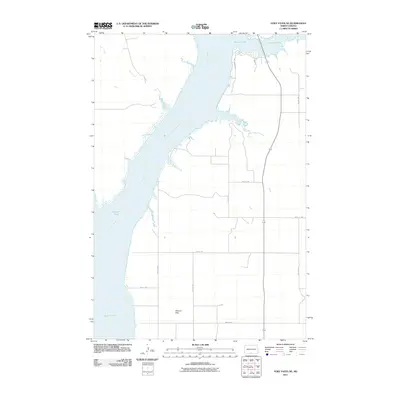
2011 Map of Fort Yates NE
USGS Topo · Published 2011About this map
The Missouri River dominates this portion of the Standing Rock Reservation area, carving a wide path through the landscape near the North Dakota-South Dakota border. Low-lying alluvial areas such as Kenel Flats and Winona Flats line the river's edges, illustrating the vast floodplains that have historically defined agricultural and settlement patterns in this Missouri Valley corridor. Tributaries including Bone Creek and Little Beaver Creek feed into the main channel, while a sparse grid of rural roads, such as 89th St SW and 10th Ave SW, provides access to the open terrain. The presence of local routes like Beaver Bay Trl and Smiley Dr suggests access points to the river and its varied shoreline features.
Find a feature on this map
16 named features on this map. Tap any name to fly to it.
Don’t see what you’re looking for? This feature index may not catch every label — zoom into the map to look around manually.
Map Details
Editions of this 2011 Fort Yates NE Map
This is the sole edition of this map. No revisions or reprints were ever made.
Other maps of this area

1954 · Bismarck
USGS Topo · 1:250,000

1958 · Bismarck
USGS Topo · 1:250,000

1968 · Cannon Ball SE
USGS Topo · 1:24,000

1968 · Fort Yates NW
USGS Topo · 1:24,000

1968 · Fort Yates SE
USGS Topo · 1:24,000

1968 · Fort Yates
USGS Topo · 1:24,000

1968 · Fort Yates NE
USGS Topo · 1:24,000

1968 · Cannon Ball SW
USGS Topo · 1:24,000

1971 · Grassna NW
USGS Topo · 1:24,000
1971 · Kiefer Buttes
USGS Topo · 1:24,000