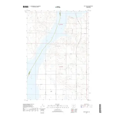
2017 Map of Fort Yates NE
USGS Topo · Published 2017About this map
Winona Flats occupies the southern reaches of this landscape, situated along the expansive eastern bank of Lake Oahe. The map delineates the boundary between Sioux Co and Emmons Co, which follows the original channel of the Missouri River. This waterway has been significantly altered by the impoundment of the Oahe Dam downstream, resulting in the broad reservoir that now defines the valley. Several drainage systems feed into the lake from the rugged breaks of the eastern shore, including Bone Cr and the winding Little Beaver Cr. The upland terrain is crisscrossed by a network of rural roads and specific local routes such as Little Beaver Creek Trl and Beaver Bay Trl, reflecting the agricultural and recreational nature of the Missouri River trench in the early 21st century.
Find a feature on this map
23 named features on this map. Tap any name to fly to it.
Don’t see what you’re looking for? This feature index may not catch every label — zoom into the map to look around manually.
Map Details
Editions of this 2017 Fort Yates NE Map
This is the sole edition of this map. No revisions or reprints were ever made.
Other maps of this area

1954 · Bismarck
USGS Topo · 1:250,000

1958 · Bismarck
USGS Topo · 1:250,000

1968 · Cannon Ball SE
USGS Topo · 1:24,000

1968 · Fort Yates NW
USGS Topo · 1:24,000

1968 · Fort Yates SE
USGS Topo · 1:24,000

1968 · Fort Yates
USGS Topo · 1:24,000

1968 · Fort Yates NE
USGS Topo · 1:24,000

1968 · Cannon Ball SW
USGS Topo · 1:24,000

1971 · Grassna NW
USGS Topo · 1:24,000
1971 · Kiefer Buttes
USGS Topo · 1:24,000