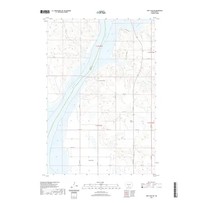
2020 Map of Fort Yates NE
USGS Topo · Published 2020About this map
Lake Oahe dominates the central corridor of this North Dakota landscape, where the Missouri River forms the natural boundary between Sioux and Emmons counties. The geography is characterized by the broad, level expanse of Winona Flats to the south and the winding drainage of Beaver Creek and Little Beaver Cr to the north. These waterways cut through the prairie, creating the distinct breaks and coulees typical of the region. Local history is anchored by the Worms Lutheran Cem, a significant genealogical site situated along the western edge of Emmons County. The land is navigated by a network of rural routes and trails, including the Beaver Bay Trl and Little Beaver Creek Trl, which follow the contours of the river valley and its tributaries.
Find a feature on this map
22 named features on this map. Tap any name to fly to it.
Don’t see what you’re looking for? This feature index may not catch every label — zoom into the map to look around manually.
Map Details
Editions of this 2020 Fort Yates NE Map
This is the sole edition of this map. No revisions or reprints were ever made.
Other maps of this area

1954 · Bismarck
USGS Topo · 1:250,000

1958 · Bismarck
USGS Topo · 1:250,000

1968 · Cannon Ball SE
USGS Topo · 1:24,000

1968 · Fort Yates NW
USGS Topo · 1:24,000

1968 · Fort Yates SE
USGS Topo · 1:24,000

1968 · Fort Yates
USGS Topo · 1:24,000

1968 · Fort Yates NE
USGS Topo · 1:24,000

1968 · Cannon Ball SW
USGS Topo · 1:24,000

1971 · Grassna NW
USGS Topo · 1:24,000
1971 · Kiefer Buttes
USGS Topo · 1:24,000