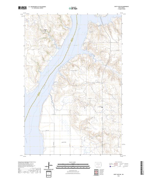
2024 Map of Fort Yates NE
USGS Topo · Published 2024About this map
The Missouri River and its massive reservoir, Lake Oahe, dominate the landscape of the Sioux and Emmons County line. This 2024 survey captures the sprawling river environment where Bone Creek and Little Beaver Creek feed into the main valley. The settlement of Cannon Ball sits in the northwest, while the broad, level terrain of Winona Flats extends across the southern portion of the sheet. For those researching local burial sites and parish history, the Worms Lutheran Cem remains a central landmark in the eastern uplands. The modern map also details access routes like Beaver Bay Trl and Little Beaver Creek Trl, which navigate the high bluffs overlooking the water. This topographical data reflects a landscape defined by the interplay between expansive prairie plateaus and the managed flow of one of America's primary waterways.
Find a feature on this map
30 named features on this map. Tap any name to fly to it.
Don’t see what you’re looking for? This feature index may not catch every label — zoom into the map to look around manually.
Map Details
Editions of this 2024 Fort Yates NE Map
This is the sole edition of this map. No revisions or reprints were ever made.
Other maps of this area

1954 · Bismarck
USGS Topo · 1:250,000

1958 · Bismarck
USGS Topo · 1:250,000

1968 · Cannon Ball SE
USGS Topo · 1:24,000

1968 · Fort Yates NW
USGS Topo · 1:24,000

1968 · Fort Yates SE
USGS Topo · 1:24,000

1968 · Fort Yates
USGS Topo · 1:24,000

1968 · Fort Yates NE
USGS Topo · 1:24,000

1968 · Cannon Ball SW
USGS Topo · 1:24,000

1971 · Grassna NW
USGS Topo · 1:24,000
1971 · Kiefer Buttes
USGS Topo · 1:24,000