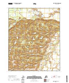
2018 Map of Fort Yukon A-3 SE
USGS Topo · Published 2018About this map
Discovery Cr flows through the upper reaches of this interior landscape in the Yukon-Koyukuk Census Area. This 2018 survey depicts a vast expanse of wetland and tundra, mapped with ten-foot contour intervals that reveal subtle rises and depressions across the northern reaches of the Discovery Creek drainage. The region is largely defined by its natural hydrography and the absence of established road infrastructure or named settlements. Public Land Survey System boundaries are clearly demarcated, showing the intersections of t15n r12e, t15n r13e, t14n r12e, and t14n r13e. This topographical study serves as a clear record of the undeveloped northern wilderness as it stood in the early twenty-first century.
Find a feature on this map
5 named features on this map. Tap any name to fly to it.
Don’t see what you’re looking for? This feature index may not catch every label — zoom into the map to look around manually.
Map Details
Editions of this 2018 Fort Yukon A-3 SE Map
This is the sole edition of this map. No revisions or reprints were ever made.
Other maps of this area

1951 · Fort Yukon
USGS Topo · 1:250,000

1951 · Circle
USGS Topo · 1:250,000

1952 · Circle D-3
USGS Topo · 1:63,360

1952 · Circle D-2
USGS Topo · 1:63,360

1955 · Circle
USGS Topo · 1:250,000

1956 · Fort Yukon A-2
USGS Topo · 1:63,360
1956 · Fort Yukon A-3
USGS Topo · 1:63,360

1956 · Fort Yukon
USGS Topo · 1:250,000

1964 · Circle
USGS Topo · 1:250,000
1966 · Fort Yukon A-2
USGS Topo · 1:63,360