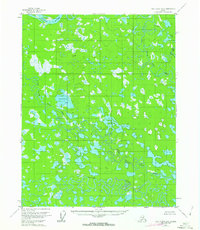
1956 Map of Fort Yukon B-5
USGS Topo · Published 1963About this map
The Yukon River cuts across the northern edge of this interior landscape, which is defined by an intricate network of wandering waterways and seasonal wetlands. The territory is dominated by the complex drainage of Beaver Creek and the meandering channels of Upper Mouth Birch Creek and Lower Mouth Birch Creek. This 1950s-era survey reveals a terrain of immense hydrological complexity, where numerous lakes such as Canvasback Lake and Scaup Lake are interconnected by sloughs and smaller streams like Tajittro Creek. The lack of road infrastructure and the presence of only a single isolated Cabin and high-point survey markers like VABM Gran 411 underscore the remote character of this region. The map provides a critical look at the natural state of the Yukon basin’s floodplain before contemporary changes, offering a detailed record of the shifting river bends and oxbows.
Find a feature on this map
11 named features on this map. Tap any name to fly to it.
Don’t see what you’re looking for? This feature index may not catch every label — zoom into the map to look around manually.
Map Details
Editions of this 1956 Fort Yukon B-5 Map
2 editions found
Other maps of this area

1951 · Fort Yukon
USGS Topo · 1:250,000

1952 · Fort Yukon C-4
USGS Topo · 1:63,360

1955 · Fort Yukon C-5
USGS Topo · 1:63,360

1956 · Fort Yukon B-6
USGS Topo · 1:63,360

1956 · Fort Yukon B-4
USGS Topo · 1:63,360

1956 · Fort Yukon A-4
USGS Topo · 1:63,360
1956 · Fort Yukon A-6
USGS Topo · 1:63,360

1956 · Fort Yukon C-5
USGS Topo · 1:63,360

1956 · Fort Yukon A-5
USGS Topo · 1:63,360

1956 · Fort Yukon B-5
USGS Topo · 1:63,360