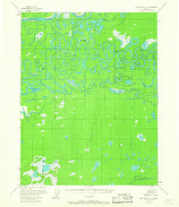
1956 Map of Fort Yukon C-1
USGS Topo · Published 1987About this map
The Porcupine River and Black River converge in a labyrinth of oxbows and meanders on this mid-century survey of the Yukon Flats. The landscape is defined by an intricate network of waterways, including Graveyard Slough, John Steven Slough, and John Kwiltik Slough, which weave between hundreds of small thaw lakes. Remote human presence is documented through isolated outposts such as Englishshoe Bar and John Ross Rifle, alongside Thompson Cabin. The dominance of the river-and-slough system suggests a seasonal and subsistence-based economy where travel was almost exclusively waterborne or dependent on winter ice. Prominent water bodies like Teiyeehoun Lake and Natrahazuivun Lake provide essential landmarks for navigation in this feature-dense alluvial plain, while VABM 580 Black serves as a rare fixed survey point in the shifting river landscape.
Find a feature on this map
18 named features on this map. Tap any name to fly to it.
Don’t see what you’re looking for? This feature index may not catch every label — zoom into the map to look around manually.
Map Details
Editions of this 1956 Fort Yukon C-1 Map
2 editions found
Other maps of this area

1951 · Fort Yukon
USGS Topo · 1:250,000

1951 · Black River
USGS Topo · 1:250,000

1952 · Fort Yukon C-2
USGS Topo · 1:63,360

1955 · Fort Yukon D-2
USGS Topo · 1:63,360

1956 · Fort Yukon C-1
USGS Topo · 1:63,360

1956 · Black River B-6
USGS Topo · 1:63,360

1956 · Black River D-6
USGS Topo · 1:63,360

1956 · Black River C-6
USGS Topo · 1:63,360

1956 · Fort Yukon B-1
USGS Topo · 1:63,360

1956 · Fort Yukon B-2
USGS Topo · 1:63,360