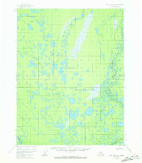
1955 Map of Fort Yukon D-4
USGS Topo · Published 1972About this map
The Venetie Indian Reservation dominates this landscape, defined by a dense network of subarctic wetlands and waterways as they appeared in the mid-1950s. The region is characterized by a labyrinth of water, including the Veh-Tenjerlow Lakes in the north and Twentymile Lake to the south. This environment dictated a reliance on seasonal transport routes, evidenced by the presence of a Sled Trail cutting through the lake-strewn terrain toward the Christian River. Small-scale human presence is recorded at the settlement of Tsukon and various cabins, suggesting the seasonal fishing and trapping patterns of the Gwich'in people. The Chandalar River clips the southwestern corner, while Marten Creek and Kocacho Creek drain the central interior, illustrating the complex hydrology of the Yukon River watershed before significant modern development.
Find a feature on this map
12 named features on this map. Tap any name to fly to it.
Don’t see what you’re looking for? This feature index may not catch every label — zoom into the map to look around manually.
Map Details
Editions of this 1955 Fort Yukon D-4 Map
3 editions found
Other maps of this area

1951 · Fort Yukon
USGS Topo · 1:250,000

1951 · Christian
USGS Topo · 1:250,000

1952 · Fort Yukon C-3
USGS Topo · 1:63,360

1952 · Fort Yukon C-4
USGS Topo · 1:63,360

1955 · Fort Yukon D-3
USGS Topo · 1:63,360

1955 · Fort Yukon D-4
USGS Topo · 1:63,360

1955 · Fort Yukon C-3
USGS Topo · 1:63,360

1955 · Fort Yukon D-5
USGS Topo · 1:63,360

1955 · Fort Yukon C-5
USGS Topo · 1:63,360

1956 · Fort Yukon C-5
USGS Topo · 1:63,360