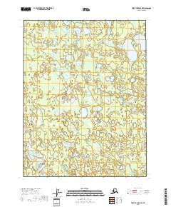
2018 Map of Fort Yukon D-5 NE
USGS Topo · Published 2018About this map
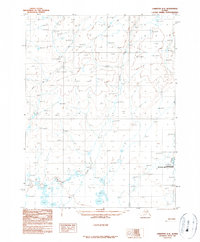
Teedriinjik River meanders across the southern portion of this landscape, a remote section of the Yukon-Koyukuk region characterized by an intricate network of wetlands and subarctic water bodies. The terrain is dominated by clusters of glacial and thermokarst lakes, including the sprawling Vunikth Lakes in the north and the isolated Vehtenjerlo Lakes to the east. These hydrologic patterns, including the course of Kocacho Cr, reflect the dynamic drainage systems common to this part of the Alaska interior. The map reveals a wild, unpopulated environment defined by its natural hydrology rather than human infrastructure, with Chahovun Lakes centered among numerous unnamed ponds and marshlands. This 2018 survey provides a precise record of the shoreline configurations and water levels during the early 21st century, essential for understanding the shifting permafrost-influenced geography of the region.
Find a feature on this map
9 named features on this map. Tap any name to fly to it.
Don’t see what you’re looking for? This feature index may not catch every label — zoom into the map to look around manually.
Map Details
Editions of this 2018 Fort Yukon D-5 NE Map
This is the sole edition of this map. No revisions or reprints were ever made.
Other maps of this area

1951 · Fort Yukon
USGS Topo · 1:250,000

1951 · Christian
USGS Topo · 1:250,000

1955 · Fort Yukon D-4
USGS Topo · 1:63,360

1955 · Fort Yukon D-5
USGS Topo · 1:63,360

1956 · Christian
USGS Topo · 1:250,000

1956 · Fort Yukon
USGS Topo · 1:250,000
1956 · Fort Yukon D-4
USGS Topo · 1:63,360
1956 · Fort Yukon D-5
USGS Topo · 1:63,360
1990 · Christian A-5
USGS Topo · 1:63,360
1990 · Christian A-4
USGS Topo · 1:63,360