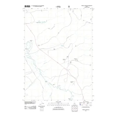
2011 Map of Fossil Canyon
USGS Topo · Published 2011About this map
Nounan Valley and the Bear River basin define the geography of this Caribou County landscape. In the early 21st century, this corridor reflects a blend of traditional ranching infrastructure and the natural hydrologic patterns of the southeastern Idaho highlands. Notable water management features include Lakey Reservoir, Cranes Reservoir, and the Stewart Ranch Dam, indicating the importance of irrigation in this semi-arid environment. The meandering path of the Bear River dominates the western portion of the map, carving through the terrain near Manson.
Find a feature on this map
25 named features on this map. Tap any name to fly to it.
Don’t see what you’re looking for? This feature index may not catch every label — zoom into the map to look around manually.
Map Details
Editions of this 2011 Fossil Canyon Map
This is the sole edition of this map. No revisions or reprints were ever made.
Other maps of this area

1909 · Montpelier
USGS Topo · 1:125,000

1911 · Montpelier
USGS Topo · 1:125,000

1911 · Slug Creek
USGS Topo · 1:62,500

1915 · Preston
USGS Topo · 1:96,000

1918 · Preston
USGS Topo · 1:125,000

1948 · Soda Springs
USGS Topo · 1:62,500

1949 · Soda Springs
USGS Topo · 1:62,500

1949 · Johnson Creek
USGS Topo · 1:24,000

1949 · Dry Valley
USGS Topo · 1:24,000
1951 · Dry Valley
USGS Topo · 1:24,000