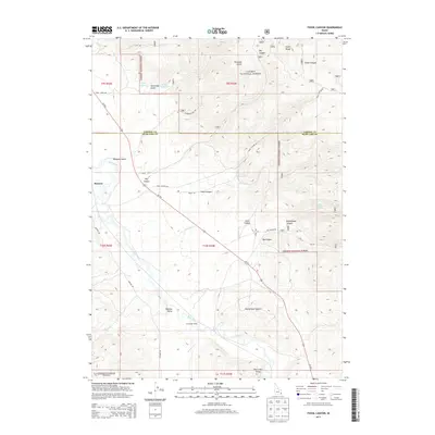
2013 Map of Fossil Canyon
USGS Topo · Published 2013About this map
Bear River winds through the southwestern corner of this Idaho landscape, providing a vital water source for the surrounding high-elevation basins. The terrain is defined by the sharp rise of the Aspen Range and the deep incisions of Fossil Canyon and Big Canyon. Settlement is concentrated in the lowland flats of Nounan Valley and near the community of Manson, where the intersection of water and transport routes shaped the local economy.
Find a feature on this map
36 named features on this map. Tap any name to fly to it.
Don’t see what you’re looking for? This feature index may not catch every label — zoom into the map to look around manually.
Map Details
Editions of this 2013 Fossil Canyon Map
This is the sole edition of this map. No revisions or reprints were ever made.
Other maps of this area

1909 · Montpelier
USGS Topo · 1:125,000

1911 · Montpelier
USGS Topo · 1:125,000

1911 · Slug Creek
USGS Topo · 1:62,500

1915 · Preston
USGS Topo · 1:96,000

1918 · Preston
USGS Topo · 1:125,000

1948 · Soda Springs
USGS Topo · 1:62,500

1949 · Soda Springs
USGS Topo · 1:62,500

1949 · Johnson Creek
USGS Topo · 1:24,000

1949 · Dry Valley
USGS Topo · 1:24,000
1951 · Dry Valley
USGS Topo · 1:24,000