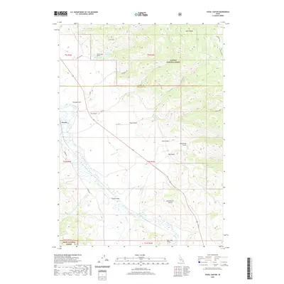
2020 Map of Fossil Canyon
USGS Topo · Published 2020About this map
Nounan Valley and the Bear River corridor dominate this landscape, where the flatlands of the Bear Lake Valley meet the rising elevations of the Aspen Range. The settlement of Manson is positioned along the western edge, serving as a focal point near the river's winding path. This area is characterized by significant topographic relief, with drainage networks including Ninemile Cr, Pearl Cr, and Skinner Cr feeding into the main river system. Water management is evident through several impoundments such as Lakey Reservoir and Cranes Reservoir, which dot the northern terrain. Much of the eastern and southern portions are protected within the Caribou National Forest and Cache National Forest, showing a transition from agricultural valley floors to high-altitude canyons like Fossil Canyon and Rattlesnake Canyon.
Find a feature on this map
36 named features on this map. Tap any name to fly to it.
Don’t see what you’re looking for? This feature index may not catch every label — zoom into the map to look around manually.
Map Details
Editions of this 2020 Fossil Canyon Map
This is the sole edition of this map. No revisions or reprints were ever made.
Other maps of this area

1909 · Montpelier
USGS Topo · 1:125,000

1911 · Montpelier
USGS Topo · 1:125,000

1911 · Slug Creek
USGS Topo · 1:62,500

1915 · Preston
USGS Topo · 1:96,000

1918 · Preston
USGS Topo · 1:125,000

1948 · Soda Springs
USGS Topo · 1:62,500

1949 · Soda Springs
USGS Topo · 1:62,500

1949 · Johnson Creek
USGS Topo · 1:24,000

1949 · Dry Valley
USGS Topo · 1:24,000
1951 · Dry Valley
USGS Topo · 1:24,000