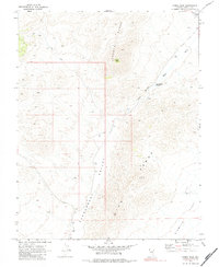
1970 Map of Fossil Peak
USGS Topo · Published 1984About this map
The Seaman Range and Hiko Range dominate this Nevada landscape, creating a dramatic corridor for the Pahranagat Valley. Surveyed in 1969 and field-checked in 1970, the map captures a topography defined by desert basins and isolated water sources. The White River flows through the Hiko Narrows, a critical geographic pinch point that funnels the waterway toward the John Wright Reservoir. To the south, the valley floor opens into Sixmile Flat, illustrating the vast, arid expanses characteristic of Lincoln County before significant modern development. The presence of Seaman Wash and Fossil Peak provides specific landmarks for geologists and researchers tracking the natural drainage and elevation patterns of the Great Basin during the late twentieth century.
Find a feature on this map
2 named features on this map. Tap any name to fly to it.
Don’t see what you’re looking for? This feature index may not catch every label — zoom into the map to look around manually.
Map Details
Editions of this 1970 Fossil Peak Map
2 editions found
Other maps of this area

1954 · Caliente
USGS Topo · 1:250,000

1959 · Caliente
USGS Topo · 1:250,000

1970 · Hiko NE
USGS Topo · 1:24,000

1970 · Hiko SE
USGS Topo · 1:24,000

1970 · Seaman Wash
USGS Topo · 1:24,000

1970 · Fossil Peak
USGS Topo · 1:24,000
1970 · White River Narrows
USGS Topo · 1:24,000

1970 · Hiko
USGS Topo · 1:24,000

1985 · Mail Summit
USGS Topo · 1:24,000
1985 · Mount Irish SE
USGS Topo · 1:24,000