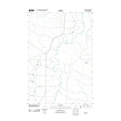
2011 Map of Foster
USGS Topo · Published 2011About this map
The Bighorn River carves through the center of this Big Horn County landscape, dictating the development and irrigation of the surrounding valley. In the early 21st century, the small settlements of Foster and Kingley serve as anchors for a rural community defined by an intricate network of waterways. The reliance on river management is evident in the presence of the Two Leggins Tunnel and a series of substantial irrigation channels including the Big Horn Low Line Canal, Wagon Box Canal, and Two Leggins Canal. The surrounding terrain is marked by numerous drainage features such as Brant Coulee, Wagon Box Coulee, and Deadmans Coulee, which suggest the variable water levels and erosive forces at play in this Montana river valley. Local travel is facilitated by a grid of named routes like Road 150 and E Big Horn River RD, connecting the remote coulees to the river's lifeblood.
Find a feature on this map
27 named features on this map. Tap any name to fly to it.
Don’t see what you’re looking for? This feature index may not catch every label — zoom into the map to look around manually.
Map Details
Editions of this 2011 Foster Map
This is the sole edition of this map. No revisions or reprints were ever made.
Other maps of this area

1894 · Fort Custer
USGS Topo · 1:125,000

1954 · Hardin
USGS Topo · 1:250,000

1954 · Forsyth
USGS Topo · 1:250,000

1957 · Hardin
USGS Topo · 1:250,000

1957 · Forsyth
USGS Topo · 1:250,000

1958 · Forsyth
USGS Topo · 1:250,000

1958 · Hardin
USGS Topo · 1:250,000

1960 · Foster
USGS Topo · 1:24,000

1960 · Ninemile Point
USGS Topo · 1:24,000

1960 · Chimney Creek
USGS Topo · 1:24,000