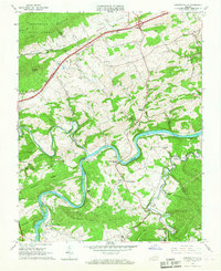
1965 Map of Fosters Falls
USGS Topo · Published 1967About this map
The New River carves a winding path through the borderlands of Pulaski and Wythe counties, defining a landscape shaped by iron-ore industry and river-bound transportation. At Fosters Falls, the river and the Norfolk and Western railroad intersect at a historic center of nineteenth-century charcoal iron production, evidenced by the Boom Furnace downstream near Kayoulah. The settlement pattern follows the fertile valleys and river bends, with older communities like Barren Springs and Bertha positioned alongside the rail line. Evidence of early landownership and rural community life is scattered throughout the ridges, from the Oglesby Cem to the Graham School and several rural sanctuaries such as Johnson Chapel and Clarks Mill Ch. While Interstate 81 crosses the northern reaches of Draper Valley, the southern portion of the map remains centered on the river's older economy of mills and mines, including High Rocks Mill and various quarries.
Find a feature on this map
56 named features on this map. Tap any name to fly to it.
Don’t see what you’re looking for? This feature index may not catch every label — zoom into the map to look around manually.
Map Details
Editions of this 1965 Fosters Falls Map
Other maps of this area

1889 · Hillsville
USGS Topo · 1:125,000

1890 · Dublin
USGS Topo · 1:125,000

1891 · Dublin
USGS Topo · 1:125,000

1892 · Hillsville
USGS Topo · 1:125,000

1896 · Hillsville
USGS Topo · 1:125,000

1930 · Max Meadows
USGS Topo · 1:62,500

1934 · Pulaski
USGS Topo · 1:48,000

1940 · Pulaski
USGS Topo · 1:62,500

1950 · Radford
USGS Topo · 1:62,500

1953 · Winston-Salem
USGS Topo · 1:250,000