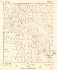
1952 Map of Fouke
USGS Topo · Published 1953About this map
Fouke serves as the primary hub of this Miller County landscape in the early 1950s, situated at the junction of several rural routes and the Texas and Pacific railroad line. The settlement pattern is defined by several rural churches and local landmarks, including Boyd Ch, Salem Ch, and Cedar Grove Ch, alongside the Gibson Cem. These community centers are connected by a network of unimproved roads and light-duty paths that navigate a complex system of waterways. Significant drainage features like Days Creek, Beech Creek, and Boggy Creek dissect the terrain, while Snake Lake rests in the southern reaches. Industrial activity is evident through numerous Gravel Pits and a prominent Pipe Line cutting diagonally across the land, illustrating the post-war infrastructure development in this corner of Arkansas.
Find a feature on this map
25 named features on this map. Tap any name to fly to it.
Don’t see what you’re looking for? This feature index may not catch every label — zoom into the map to look around manually.
Map Details
Editions of this 1952 Fouke Map
5 editions found
Other maps of this area

1907 · Atlanta
USGS Topo · 1:62,500

1909 · Texarkana
USGS Topo · 1:62,500

1910 · Atlanta
USGS Topo · 1:62,500

1952 · Mandeville
USGS Topo · 1:24,000

1952 · Doddridge NW
USGS Topo · 1:24,000

1952 · Fouke SE
USGS Topo · 1:24,000

1952 · Doddridge NE
USGS Topo · 1:24,000

1952 · Fouke
USGS Topo · 1:24,000

1952 · Fouke NE
USGS Topo · 1:24,000

1953 · Texarkana
USGS Topo · 1:250,000