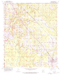
1952 Map of Fouke
USGS Topo · Published 1971About this map
Fouke serves as the primary hub in this southwest Arkansas landscape, situated along a prominent rail line in a region defined by a dense network of creek drainages. The topography is marked by the meandering paths of Days Creek, Beech Creek, and Boggy Creek, which carve through the townships of Garland and Cleveland. Local social life in the early 1950s is anchored by numerous rural congregations, including Salem Ch, Sylverino Ch, and Boyd Ch, often found near small junctions like Berryman Crossroads. For genealogists, the presence of the Gibson Cem and small settlements like Boyd provides critical spatial data for tracing family roots in Miller County. The map also reveals the local extractive industry through several Gravel Pits scattered near the rail corridors, reflecting the area's mid-century economic activities.
Find a feature on this map
25 named features on this map. Tap any name to fly to it.
Don’t see what you’re looking for? This feature index may not catch every label — zoom into the map to look around manually.
Map Details
Editions of this 1952 Fouke Map
5 editions found
Other maps of this area

1907 · Atlanta
USGS Topo · 1:62,500

1909 · Texarkana
USGS Topo · 1:62,500

1910 · Atlanta
USGS Topo · 1:62,500

1952 · Mandeville
USGS Topo · 1:24,000

1952 · Doddridge NW
USGS Topo · 1:24,000

1952 · Fouke SE
USGS Topo · 1:24,000

1952 · Doddridge NE
USGS Topo · 1:24,000

1952 · Fouke
USGS Topo · 1:24,000

1952 · Fouke NE
USGS Topo · 1:24,000

1953 · Texarkana
USGS Topo · 1:250,000