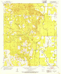
1952 Map of Fouke SE
USGS Topo · Published 1953About this map
The floodplains and terraces of the Red River valley in Miller County dominate this 1952 study, where agriculture and early oil exploration defined the local economy. A complex network of water features, including McKinney Bayou, Old Channel Bayou, and the Fish Lake oxbow, illustrates the shifting hydrology of this riverine landscape. Evidence of the region’s hydraulic engineering is visible through the prominent Levee and Pipe Line infrastructure that cuts across the terrain near the Gaging Station.
Find a feature on this map
28 named features on this map. Tap any name to fly to it.
Don’t see what you’re looking for? This feature index may not catch every label — zoom into the map to look around manually.
Map Details
Editions of this 1952 Fouke SE Map
4 editions found
Other maps of this area

1952 · Mandeville
USGS Topo · 1:24,000

1952 · Garland
USGS Topo · 1:24,000

1952 · Doddridge NW
USGS Topo · 1:24,000

1952 · Fouke SE
USGS Topo · 1:24,000

1952 · Doddridge NE
USGS Topo · 1:24,000

1952 · Fouke
USGS Topo · 1:24,000

1952 · Canfield
USGS Topo · 1:24,000

1952 · Fouke NE
USGS Topo · 1:24,000

1952 · Boyd Hill
USGS Topo · 1:24,000

1953 · El Dorado
USGS Topo · 1:250,000