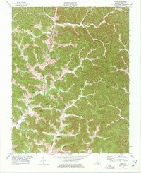
1974 Map of Fount
USGS Topo · Published 1975About this map
The deep valleys of the Cumberland Plateau characterize this Knox County landscape, where settlements like Fount and Girdler developed along the winding watercourses. The transportation network of the mid-1970s is defined by the Louisville and Nashville railroad and KY 11, which follow the level ground created by Stinking Creek and its various forks. This era shows an economy transitioning through heavy resource extraction, evidenced by the numerous strip mines and oil wells scattered across the ridges. Local genealogy is deeply etched into the terrain through a high density of family burial grounds, such as Asher Cem and Messer Cem, alongside long-standing community centers like Trace Branch Ch and Dripping Spring Ch. The map captures the intricate relationship between the steep topography of Cole Ridge and the historic homesteads established in hollows like Hog Wallow Hollow.
Find a feature on this map
116 named features on this map. Tap any name to fly to it.
Don’t see what you’re looking for? This feature index may not catch every label — zoom into the map to look around manually.
Map Details
Editions of this 1974 Fount Map
This is the sole edition of this map. No revisions or reprints were ever made.
Other maps of this area

1886 · Cumberland Gap
USGS Topo · 1:125,000

1888 · Cumberland Gap
USGS Topo · 1:125,000

1891 · Manchester
USGS Topo · 1:125,000

1891 · Cumberland Gap
USGS Topo · 1:125,000

1903 · Pineville
USGS Topo · 1:48,000

1952 · Barbourville
USGS Topo · 1:24,000

1952 · Heidrick
USGS Topo · 1:24,000

1952 · Hima
USGS Topo · 1:24,000

1952 · Blackwater
USGS Topo · 1:24,000

1952 · Fount
USGS Topo · 1:24,000