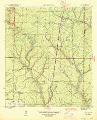
1945 Map of Fountain
USGS Topo · Published 1945About this map
Fountain serves as a primary rail point along the Atlanta and St Andrews Bay railroad in this 1945 survey of Bay County. The landscape is defined by its complex hydrology, with the Econfina River carving through the northwest and the winding courses of Bear Creek and Juniper Creek dominating the eastern half of the quadrangle. The map reveals a transition from natural water features like Open Pond and Bear Pond to the human-engineered infrastructure of the era, including the C C C Road and the Youngstown Lookout Tower. Traces of earlier industrial activity are visible in the Old Tramroad near the southern boundary, while the settlement of Vicksburg appears in the southwest corner along County Road No 3. This record provides an exact look at the drainage patterns and transportation network of North Florida before post-war development.
Find a feature on this map
19 named features on this map. Tap any name to fly to it.
Don’t see what you’re looking for? This feature index may not catch every label — zoom into the map to look around manually.
Map Details
Editions of this 1945 Fountain Map
3 editions found
Other maps of this area

1944 · Bayhead
USGS Topo · 1:24,000

1944 · Bennett
USGS Topo · 1:24,000

1945 · Juniper Creek
USGS Topo · 1:31,680

1945 · Youngstown
USGS Topo · 1:31,680

1945 · Bennett
USGS Topo · 1:31,680

1945 · Bayhead
USGS Topo · 1:31,680

1945 · Broad Branch
USGS Topo · 1:31,680

1945 · Fountain
USGS Topo · 1:31,680

1950 · Gap Lake
USGS Topo · 1:24,000

1951 · Gap Pond
USGS Topo · 1:24,000