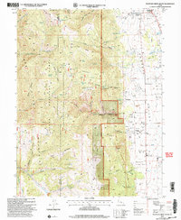
2001 Map of Fountain Green South
USGS Topo · Published 2004About this map
The Sanpete Valley serves as a prominent agricultural and settlement corridor at the base of the high plateaus in this 2001 revision. Small communities like Fountain Green and the cluster at Freedom are clearly delineated, reflecting the area’s longstanding Mormon pioneer heritage and rural layout. To the west, the landscape rises sharply into the Manti-La Sal National Forest and Uinta National Forest, where the terrain is carved by complex drainages like Maple Canyon and Pigeon Hollow. The inclusion of Skyline Drive along the high ridges highlights the importance of this route for forest management and mountain access. Genealogists will find the local Cem near Freedom particularly useful for locating family sites, while geographic features such as Devils Gate and Hamburger Lake provide specific landmarks within the high-elevation flats and ridges.
Find a feature on this map
57 named features on this map. Tap any name to fly to it.
Don’t see what you’re looking for? This feature index may not catch every label — zoom into the map to look around manually.
Map Details
Editions of this 2001 Fountain Green South Map
This is the sole edition of this map. No revisions or reprints were ever made.
Other maps of this area

1885 · Manti
USGS Topo · 1:250,000

1895 · Manti
USGS Topo · 1:250,000

1951 · Moroni
USGS Topo · 1:62,500

1951 · Nephi
USGS Topo · 1:62,500

1956 · Price
USGS Topo · 1:250,000

1960 · Price
USGS Topo · 1:250,000

1962 · Price
USGS Topo · 1:250,000

1965 · Chriss Canyon
USGS Topo · 1:24,000

1965 · Wales
USGS Topo · 1:24,000

1966 · Chester
USGS Topo · 1:24,000