
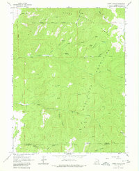
1965 Map of Chriss Canyon
USGS Topo · Published 1967About this map
The Sanpitch Mountains dominate this high-elevation terrain within the Uinta National Forest during the mid-1960s. The landscape is defined by steep drainages and isolated landmarks such as Big Baldy and Little Red Hill. Human activity in these uplands is limited to a few specific sites, including a Radio Facility in the northern section and scattered infrastructure like a Corral and a Quarry.
Find a feature on this map
33 named features on this map. Tap any name to fly to it.
Don’t see what you’re looking for? This feature index may not catch every label — zoom into the map to look around manually.
Map Details
Editions of this 1965 Chriss Canyon Map
2 editions found
Other maps of this area

1885 · Manti
USGS Topo · 1:250,000

1895 · Manti
USGS Topo · 1:250,000

1951 · Moroni
USGS Topo · 1:62,500

1951 · Nephi
USGS Topo · 1:62,500

1956 · Price
USGS Topo · 1:250,000

1960 · Price
USGS Topo · 1:250,000

1962 · Price
USGS Topo · 1:250,000
1965 · Hells Kitchen Canyon SW
USGS Topo · 1:24,000

1965 · Hells Kitchen Canyon SE
USGS Topo · 1:24,000
1965 · Skinner Peaks
USGS Topo · 1:24,000