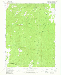
1965 Map of Chriss Canyon
USGS Topo · Published 1980About this map
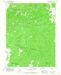
The Wasatch Mountains define the high-elevation landscape of this mid-1960s survey, marking a transition from the Uinta National Forest down toward the central Utah valleys. Steep drainage systems like Chriss Canyon and Deep Canyon dominate the topography, illustrating the complex watershed patterns that feed into Chriss Creek and Little Salt Creek. The map documents a period of light infrastructure in the backcountry, where movement relied on a network of Pack Trails and Jeep Trails rather than developed roads.
Find a feature on this map
71 named features on this map. Tap any name to fly to it.
Don’t see what you’re looking for? This feature index may not catch every label — zoom into the map to look around manually.
Map Details
Editions of this 1965 Chriss Canyon Map
2 editions found
Other maps of this area

1885 · Manti
USGS Topo · 1:250,000

1895 · Manti
USGS Topo · 1:250,000
1951 · Moroni
USGS Topo · 1:62,500
1951 · Nephi
USGS Topo · 1:62,500

1956 · Price
USGS Topo · 1:250,000

1960 · Price
USGS Topo · 1:250,000

1962 · Price
USGS Topo · 1:250,000
1965 · Hells Kitchen Canyon SW
USGS Topo · 1:24,000
1965 · Chriss Canyon
USGS Topo · 1:24,000
1965 · Hells Kitchen Canyon SE
USGS Topo · 1:24,000