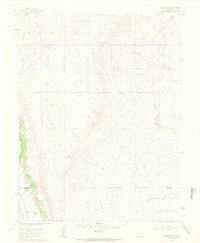
1961 Map of Fountain SE
USGS Topo · Published 1963About this map
Fountain Creek winds through the southwestern corner of this landscape, defining a corridor of activity marked by the Denver and Rio Grande Western railroad. This early 1960s survey illustrates a rural ranching economy where family-named holdings like Hammer Ranch, Williams Ranch, and Paige Ranch are scattered across the plains. The presence of the Hanover Ditch No 1 alongside Chico Creek indicates the importance of water management for sustaining agriculture in this semi-arid region near the El Paso and Pueblo County line. The terrain is further defined by ephemeral waterways such as Williams Creek and a localized Gravel Pit, providing a detailed look at the infrastructure of central Colorado before modern expansion. Transportation is anchored by Hanover Road and Overton Road, which connect these isolated homesteads and ranching operations.
Find a feature on this map
13 named features on this map. Tap any name to fly to it.
Don’t see what you’re looking for? This feature index may not catch every label — zoom into the map to look around manually.
Map Details
Editions of this 1961 Fountain SE Map
4 editions found
Other maps of this area

1891 · Pueblo
USGS Topo · 1:125,000

1891 · Nepesta
USGS Topo · 1:125,000

1893 · Nepesta
USGS Topo · 1:125,000

1893 · Big Springs
USGS Topo · 1:125,000

1893 · Colorado Springs
USGS Topo · 1:125,000

1894 · Pueblo
USGS Topo · 1:125,000

1896 · Pueblo
USGS Topo · 1:125,000

1897 · Pueblo
USGS Topo · 1:125,000

1904 · Nepesta
USGS Topo · 1:125,000

1909 · Colorado Springs
USGS Topo · 1:125,000