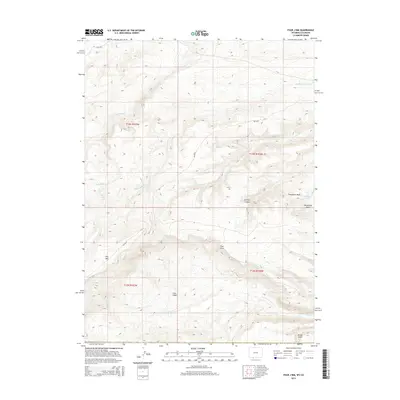
2015 Map of Four J Rim
USGS Topo · Published 2015About this map
Four J Rim dominates this high-altitude landscape on the Wyoming-Colorado border, serving as a significant topographic divide. The area is defined by a series of basins and dramatic elevation shifts, most notably at Pine Mtn and the adjacent Four J Basin. Water is a critical and scarce element here, as evidenced by the concentration of named water sources like Big Spring, Goat Spring, Bell Spring, and the small Pine Lake. These springs are vital markers for navigation and survival in a terrain otherwise characterized by dry washes such as Horseshoe Wash and deep incisions like Scrivner Canyon.
Find a feature on this map
27 named features on this map. Tap any name to fly to it.
Don’t see what you’re looking for? This feature index may not catch every label — zoom into the map to look around manually.
Map Details
Editions of this 2015 Four J Rim Map
This is the sole edition of this map. No revisions or reprints were ever made.
Other maps of this area

1885 · Ashley
USGS Topo · 1:250,000

1952 · Willow Creek Butte
USGS Topo · 1:24,000

1954 · Vernal
USGS Topo · 1:250,000

1954 · Rock Springs
USGS Topo · 1:250,000

1958 · Vernal
USGS Topo · 1:250,000

1958 · Rock Springs
USGS Topo · 1:250,000

1960 · Vernal
USGS Topo · 1:250,000

1962 · Rock Springs
USGS Topo · 1:250,000
1963 · Titsworth Gap
USGS Topo · 1:24,000

1963 · Four J Rim
USGS Topo · 1:24,000