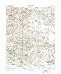
1908 Map of Four Oaks
USGS Topo · Published 1944About this map
Four Oaks serves as the central hub of this eastern North Carolina landscape, where the Atlantic Coast Line railroad dictates the local geography. The surrounding area in Johnston County is a network of rural crossroads and community centers like Peacocks Crossroads and Blackmon Crossroads. The drainage of the Neuse River and its tributaries, including Hannah Creek and Mill Creek, once supported a water-powered economy evidenced by Lee's Mill and Creeches Mill. Crossing these waters required established infrastructure such as Pierce's Ferry and Barefoot Bridge, while the presence of the Bentonville Bradley PO provides a significant touchstone for researchers of the American Civil War era. Numerous small congregations and educational sites, from the New Zealand Church to the Wentworth School, illustrate the dense social fabric of these early 20th-century farming townships.
Find a feature on this map
97 named features on this map. Tap any name to fly to it.
Don’t see what you’re looking for? This feature index may not catch every label — zoom into the map to look around manually.
Map Details
Editions of this 1908 Four Oaks Map
3 editions found
Other maps of this area

1902 · Kenly
USGS Topo · 1:62,500

1903 · Kenly
USGS Topo · 1:62,500

1906 · Four Oaks
USGS Topo · 1:48,000

1908 · Four Oaks
USGS Topo · 1:62,500

1909 · Coharie
USGS Topo · 1:62,500

1953 · Raleigh
USGS Topo · 1:250,000

1954 · Raleigh
USGS Topo · 1:250,000

1964 · Selma
USGS Topo · 1:62,500

1964 · Edmondson
USGS Topo · 1:24,000

1964 · Garner
USGS Topo · 1:62,500