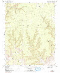
1968 Map of Fourmile Bench
USGS Topo · Published 1991About this map
Fourmile Bench dominates this high plateau in Kane County, defined by its complex drainage network and elevated landforms. Photogrammetric methods capture the intricate system of canyons and forks, including the prominent John Henry Canyon and the winding course of Fourmile Canyon Creek. The presence of a remote Landing Strip on the upper plateau suggests the isolation of this terrain, where access was limited to unimproved roads during the late 1960s.
Find a feature on this map
13 named features on this map. Tap any name to fly to it.
Don’t see what you’re looking for? This feature index may not catch every label — zoom into the map to look around manually.
Map Details
Editions of this 1968 Fourmile Bench Map
3 editions found
Other maps of this area

1886 · Escalante
USGS Topo · 1:250,000

1922 · Upper Last Chance
USGS Topo · 1:63,360

1953 · Nipple Butte
USGS Topo · 1:62,500

1954 · Paria
USGS Topo · 1:62,500

1956 · Escalante
USGS Topo · 1:250,000

1960 · Escalante
USGS Topo · 1:250,000

1964 · Horse Flat
USGS Topo · 1:24,000
1964 · Butler Valley
USGS Topo · 1:24,000

1968 · Fourmile Bench
USGS Topo · 1:24,000
1968 · Petes Cove
USGS Topo · 1:24,000