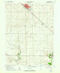
1962 Map of Fowler
USGS Topo · Published 1964About this map
Fowler stands as the central hub of this Benton County landscape, where the local Courthouse anchors the town grid. The mid-century geography is defined by a dense network of transportation, including the New York Central Railroad which cuts diagonally through the county, passing through Swanington. Further south, the Chicago and St Louis Railroad services the smaller settlements of Chase and Fargo before reaching the larger community of Oxford. The transition from industrial rail lines to the natural drainage of Pine Creek and Goose Creek illustrates the agricultural character of the region. Genealogists will find interest in localized sites such as Perigo Cem and Oxford Cem, while the presence of an Old Railroad Grade north of Oxford points to a shifting landscape as earlier transit routes were superseded.
Find a feature on this map
20 named features on this map. Tap any name to fly to it.
Don’t see what you’re looking for? This feature index may not catch every label — zoom into the map to look around manually.
Map Details
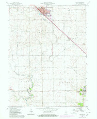
Editions of this 1962 Fowler Map
2 editions found
Other maps of this area

1953 · Danville
USGS Topo · 1:250,000

1955 · Danville
USGS Topo · 1:250,000

1956 · Danville
USGS Topo · 1:250,000

1961 · Chatterton
USGS Topo · 1:24,000

1961 · Tab
USGS Topo · 1:24,000

1961 · Pine Village
USGS Topo · 1:24,000

1962 · Mount Gilboa
USGS Topo · 1:24,000

1962 · Wadena
USGS Topo · 1:24,000

1962 · Templeton
USGS Topo · 1:24,000

1962 · Boswell
USGS Topo · 1:24,000