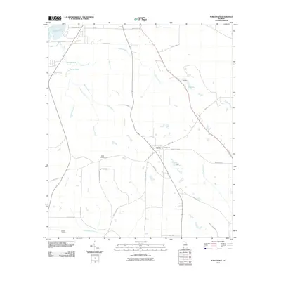
2011 Map of Fowlstown
USGS Topo · Published 2011About this map
Fowlstown and its surrounding agricultural lands define this section of Decatur County, Georgia. The landscape is characterized by a dense network of watercourses and ponds, including the southern edge of Lake Seminole in the northwest and the winding paths of Spring Creek and Fourmile Creek. The map provides significant genealogical value through the documentation of Green Shade Cemetery and Peterson Cemetery, alongside the centralized Fowlstown Post Office. Transportation corridors such as the Tallahassee Hwy and Bower Station Rd connect the scattered homesteads. Smaller water bodies like Rich Lake and Davis Lake, both featuring labeled dams, highlight local water management for the area's farms and residences. This survey captures the rural character of the region, where family names are often preserved in the road network, including Robert Stephens Rd and Johnny Skipper Rd.
Find a feature on this map
43 named features on this map. Tap any name to fly to it.
Don’t see what you’re looking for? This feature index may not catch every label — zoom into the map to look around manually.
Map Details
Editions of this 2011 Fowlstown Map
This is the sole edition of this map. No revisions or reprints were ever made.
Other maps of this area

1954 · Tallahassee
USGS Topo · 1:250,000

1955 · Bainbridge
USGS Topo · 1:62,500

1955 · Whigham
USGS Topo · 1:62,500

1955 · Mt Pleasant
USGS Topo · 1:24,000

1956 · Havana North
USGS Topo · 1:24,000

1956 · Dogtown
USGS Topo · 1:24,000

1959 · Tallahassee
USGS Topo · 1:250,000

1960 · Tallahassee
USGS Topo · 1:250,000
1974 · Bainbridge
USGS Topo · 1:24,000
1974 · Faceville
USGS Topo · 1:24,000