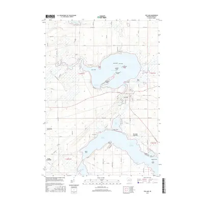
2015 Map of Fox Lake
USGS Topo · Published 2015About this map
Fox Lake dominates this Dodge County landscape, characterized by its numerous named islands and peninsulas such as Dead Island, Lone Island, and McFetridge Island. The settlement of Fox Lake sits on the southern shore, while smaller communities like Lyndon Dale and Fox Lake Junction occupy the surrounding lake margins and intersections. To the south, the northern reaches of Beaver Dam Lake transition into a complex of wetlands and inlets, including Hickory Bay, and the site of the Trestle Works.
Find a feature on this map
101 named features on this map. Tap any name to fly to it.
Don’t see what you’re looking for? This feature index may not catch every label — zoom into the map to look around manually.
Map Details
Editions of this 2015 Fox Lake Map
This is the sole edition of this map. No revisions or reprints were ever made.
Other maps of this area

1955 · Randolph
USGS Topo · 1:62,500

1955 · Columbus
USGS Topo · 1:62,500

1955 · Beaver Dam
USGS Topo · 1:62,500

1955 · Fox Lake
USGS Topo · 1:62,500

1957 · Madison
USGS Topo · 1:250,000

1960 · Madison
USGS Topo · 1:250,000

1975 · Beaver Dam NE
USGS Topo · 1:24,000

1980 · Fond Du Lac
USGS Topo · 1:100,000

1980 · Lost Lake
USGS Topo · 1:24,000
1980 · Brandon
USGS Topo · 1:24,000