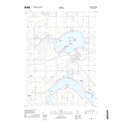
2018 Map of Fox Lake
USGS Topo · Published 2018About this map
Fox Lake and the northern reaches of Beaver Dam Lake dominate this Dodge County landscape, characterized by a complex shoreline of points and islands. The city of Fox Lake sits at the center, serving as a hub for small lakeside developments like Lyndon Dale and Delbern Acres. To the west, the settlements of Randolph and South Randolph sit amidst an agricultural grid, with long-established sites like Hall Cem and Lake Emily Cem providing valuable points of reference for local historians.
Find a feature on this map
100 named features on this map. Tap any name to fly to it.
Don’t see what you’re looking for? This feature index may not catch every label — zoom into the map to look around manually.
Map Details
Editions of this 2018 Fox Lake Map
This is the sole edition of this map. No revisions or reprints were ever made.
Other maps of this area

1955 · Randolph
USGS Topo · 1:62,500

1955 · Columbus
USGS Topo · 1:62,500

1955 · Beaver Dam
USGS Topo · 1:62,500

1955 · Fox Lake
USGS Topo · 1:62,500

1957 · Madison
USGS Topo · 1:250,000

1960 · Madison
USGS Topo · 1:250,000

1975 · Beaver Dam NE
USGS Topo · 1:24,000

1980 · Fond Du Lac
USGS Topo · 1:100,000

1980 · Lost Lake
USGS Topo · 1:24,000
1980 · Brandon
USGS Topo · 1:24,000