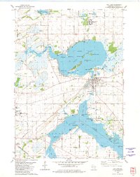
1980 Map of Fox Lake
USGS Topo · Published 1981About this map
The waters of Fox Lake and the northern reaches of Beaver Dam Lake dominate this Dodge County landscape, characterized by an intricate shoreline of points and islands. In 1980, the city of Fox Lake sits at the eastern edge of its namesake water body, serving as a hub between the Chicago Milwaukee St Paul and Pacific and the Chicago and North Western rail lines. The map reveals a transition from the structured residential blocks of the city to the recreational and institutional outskirts, including the Fox Lake Country Club and the State Correctional Institution near Lake Emily. Genealogists may find value in the placement of several rural burying grounds, such as Lake Emily Cem and Hall Cem, while the industrial legacy of the region is noted through multiple gravel pits and the Trestle Works bay area.
Find a feature on this map
80 named features on this map. Tap any name to fly to it.
Don’t see what you’re looking for? This feature index may not catch every label — zoom into the map to look around manually.
Map Details
Editions of this 1980 Fox Lake Map
This is the sole edition of this map. No revisions or reprints were ever made.
Other maps of this area

1955 · Randolph
USGS Topo · 1:62,500

1955 · Columbus
USGS Topo · 1:62,500

1955 · Beaver Dam
USGS Topo · 1:62,500

1955 · Fox Lake
USGS Topo · 1:62,500

1957 · Madison
USGS Topo · 1:250,000

1960 · Madison
USGS Topo · 1:250,000

1975 · Beaver Dam NE
USGS Topo · 1:24,000

1980 · Fond Du Lac
USGS Topo · 1:100,000

1980 · Lost Lake
USGS Topo · 1:24,000
1980 · Brandon
USGS Topo · 1:24,000