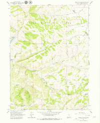
1964 Map of Francis Canyon
USGS Topo · Published 1979About this map
Cache National Forest dominates this mountain landscape where the borders of Morgan, Rich, and Summit counties converge. The drainage of Francis Canyon and its many offshoots, such as South Fork and Beaver Dam Hollow, define the hydrology of the region. The western edge of the sheet shows the engineering impact of the mid-century with Lost Creek Reservoir, while the surrounding terrain is marked by family-named landmarks and old-growth quaking aspen groves.
Find a feature on this map
34 named features on this map. Tap any name to fly to it.
Don’t see what you’re looking for? This feature index may not catch every label — zoom into the map to look around manually.
Map Details
Editions of this 1964 Francis Canyon Map
3 editions found
Other maps of this area

1954 · Ogden
USGS Topo · 1:250,000

1958 · Ogden
USGS Topo · 1:250,000

1960 · Ogden
USGS Topo · 1:250,000

1964 · Lost Creek Dam
USGS Topo · 1:24,000

1964 · Francis Canyon
USGS Topo · 1:24,000
1964 · Henefer
USGS Topo · 1:24,000
1964 · Heiners Creek
USGS Topo · 1:24,000

1968 · Horse Ridge
USGS Topo · 1:24,000

1968 · Shearing Corral
USGS Topo · 1:24,000

1968 · Mc Kay Hollow
USGS Topo · 1:24,000