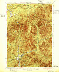
1932 Map of Franconia
USGS Topo · Published 1932About this map
The Gale River and Pemigewasset River valleys define the settlement patterns of this White Mountains region as they appeared in the early 1930s. The village of Lincoln serves as a local industrial hub, anchored by the Boston and Maine RR and the East Branch Pemigewasset River, while Franconia and North Woodstock occupy the northern and southern entries to the notch. The mapping highlights the early recreational infrastructure of the era, from the Profile Golf Club and Franconia Bike Path to numerous mountain shelters and trails like the Greenleaf Trail. Notable landmarks such as The Basin, Echo Lake, and Profile Lake sit along the primary corridor of the Daniel Webster Highway No. 3, which was the main artery through the steep terrain of the Franconia and Bethlehem ranges.
Find a feature on this map
119 named features on this map. Tap any name to fly to it.
Don’t see what you’re looking for? This feature index may not catch every label — zoom into the map to look around manually.
Map Details
Editions of this 1932 Franconia Map
5 editions found

Other maps of this area

1893 · Mt. Washington
USGS Topo · 1:62,500

1895 · Crawford Notch
USGS Topo · 1:62,500

1896 · Mt. Washington
USGS Topo · 1:62,500

1896 · Crawford Notch
USGS Topo · 1:62,500

1900 · Whitefield
USGS Topo · 1:62,500

1928 · Plymouth
USGS Topo · 1:62,500

1928 · Rumney
USGS Topo · 1:62,500

1929 · Moosilauke
USGS Topo · 1:62,500

1929 · Franconia
USGS Topo · 1:62,500

1931 · Littleton
USGS Topo · 1:62,500