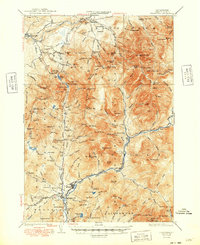
1932 Map of Franconia
USGS Topo · Published 1948About this map
Franconia Notch serves as the focal point of this 1929 survey, where the rugged topography of the White Mountain National Forest is documented in sharp detail. The map reveals a landscape defined by dramatic elevation changes, from the heights of Mt Lafayette and Mt Lincoln down to the narrow corridors of the Pemigewasset River and Gale River. A distinct logging economy is evident through the presence of the Logging R R snaking along the East Branch Pemigewasset River, while the emerging recreation industry is marked by the Profile Golf Club, the Appalachian Trail, and several backcountry shelters. Civil engineering is noted at the U S G S Gage Sta and various benchmarks in Lincoln and North Woodstock, providing a technical look at the region's infrastructure before mid-century expansion.
Find a feature on this map
161 named features on this map. Tap any name to fly to it.
Don’t see what you’re looking for? This feature index may not catch every label — zoom into the map to look around manually.
Map Details
Editions of this 1932 Franconia Map
5 editions found

Other maps of this area

1893 · Mt. Washington
USGS Topo · 1:62,500

1895 · Crawford Notch
USGS Topo · 1:62,500

1896 · Mt. Washington
USGS Topo · 1:62,500

1896 · Crawford Notch
USGS Topo · 1:62,500

1900 · Whitefield
USGS Topo · 1:62,500

1928 · Plymouth
USGS Topo · 1:62,500

1928 · Rumney
USGS Topo · 1:62,500

1929 · Moosilauke
USGS Topo · 1:62,500

1929 · Franconia
USGS Topo · 1:62,500

1931 · Littleton
USGS Topo · 1:62,500