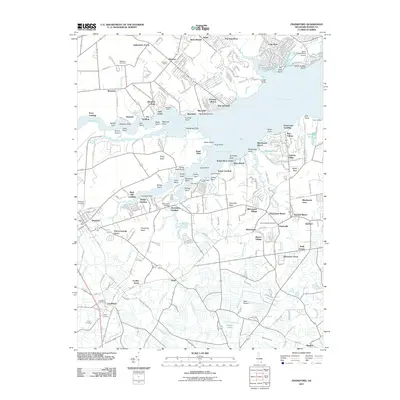
2011 Map of Frankford
USGS Topo · Published 2011About this map
Indian River Bay and the interconnected waters of Indian River and Pepper Creek dominate this coastal landscape, where the peninsula's geography is defined by a series of named points and necks. From Pot Nets Point in the north to White Neck in the east, the shoreline reveals a complex network of small landings and recreational sites like Camp Otonka and Rosedale Beach. Inland, the settlements of Frankford, Dagsboro, and Clarksville are surrounded by agricultural developments such as Indiantown Farms and Cuelen Acres. Genealogists will find several burial grounds documented, including Saint Georges Cemetery and Millsboro Cemetery, alongside local landmarks like Harmons School. The map also illustrates the region's aviation history through White House Farm Airport and West Airport, highlighting how transportation and leisure have shaped this section of Sussex County.
Find a feature on this map
107 named features on this map. Tap any name to fly to it.
Don’t see what you’re looking for? This feature index may not catch every label — zoom into the map to look around manually.
Map Details
Editions of this 2011 Frankford Map
This is the sole edition of this map. No revisions or reprints were ever made.
Other maps of this area

1901 · Ocean City
USGS Topo · 1:62,500

1902 · Pittsville
USGS Topo · 1:62,500

1917 · Millsboro
USGS Topo · 1:62,500

1918 · Rehoboth
USGS Topo · 1:62,500

1938 · Millsboro
USGS Topo · 1:62,500

1938 · Rehoboth
USGS Topo · 1:62,500

1942 · Ocean City
USGS Topo · 1:62,500

1942 · Whaleysville
USGS Topo · 1:24,000

1943 · Selbyville
USGS Topo · 1:31,680
1943 · Whaleysville
USGS Topo · 1:31,680