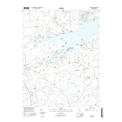
2016 Map of Frankford
USGS Topo · Published 2016About this map
Indian River Bay and its complex network of tidal guts and points define this coastal Delaware landscape, where the Delmarva Peninsula meets the Atlantic tidewaters. Small inland communities like Frankford, Dagsboro, and Omar are connected by a grid of rural roads, while the shoreline is dotted with established waterfront settlements including Oak Orchard and Riverdale. The map captures a detailed inventory of the region's burial grounds, such as Millsboro Cem and Saint Georges Cem, which serve as vital landmarks for local genealogical research.
Find a feature on this map
272 named features on this map. Tap any name to fly to it.
Don’t see what you’re looking for? This feature index may not catch every label — zoom into the map to look around manually.
Map Details
Editions of this 2016 Frankford Map
This is the sole edition of this map. No revisions or reprints were ever made.
Other maps of this area

1901 · Ocean City
USGS Topo · 1:62,500

1902 · Pittsville
USGS Topo · 1:62,500

1917 · Millsboro
USGS Topo · 1:62,500

1918 · Rehoboth
USGS Topo · 1:62,500

1938 · Millsboro
USGS Topo · 1:62,500

1938 · Rehoboth
USGS Topo · 1:62,500

1942 · Ocean City
USGS Topo · 1:62,500

1942 · Whaleysville
USGS Topo · 1:24,000

1943 · Selbyville
USGS Topo · 1:31,680
1943 · Whaleysville
USGS Topo · 1:31,680