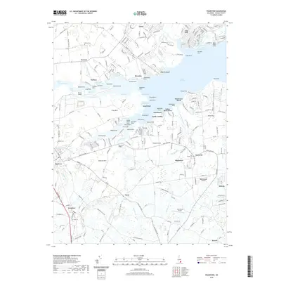
2019 Map of Frankford
USGS Topo · Published 2019About this map
Indian River Bay dominates the landscape of this Sussex County coastal region, where a complex network of points and necks defines the interface between land and water. The northeastern reaches include waterfront communities like Long Neck and Oak Orchard, while the south is anchored by the historic inland settlements of Frankford and Dagsboro. Along the serpentine banks of Vines Creek and Pepper Creek, numerous points such as Ballast Point and Holland Point mark the winding coastline. Family history is etched into the terrain at sites like Saint Georges Cem near Clarksville and Millsboro Cem to the northwest. This modern survey illustrates how traditional agriculture and rural crossroads like Omar and Bayard coexist with more recent residential developments such as Sherwood Acres. The landscape remains tied to its maritime roots through features like Ferry Cove and the Townsend Bridge, which spans the transition from tidal marsh to established farmland.
Find a feature on this map
263 named features on this map. Tap any name to fly to it.
Don’t see what you’re looking for? This feature index may not catch every label — zoom into the map to look around manually.
Map Details
Editions of this 2019 Frankford Map
This is the sole edition of this map. No revisions or reprints were ever made.
Other maps of this area

1901 · Ocean City
USGS Topo · 1:62,500

1902 · Pittsville
USGS Topo · 1:62,500

1917 · Millsboro
USGS Topo · 1:62,500

1918 · Rehoboth
USGS Topo · 1:62,500

1938 · Millsboro
USGS Topo · 1:62,500

1938 · Rehoboth
USGS Topo · 1:62,500

1942 · Ocean City
USGS Topo · 1:62,500

1942 · Whaleysville
USGS Topo · 1:24,000

1943 · Selbyville
USGS Topo · 1:31,680
1943 · Whaleysville
USGS Topo · 1:31,680