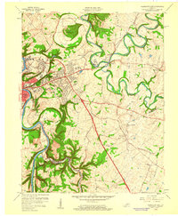
1959 Map of Frankfort East
USGS Topo · Published 1960About this map
Frankfort and its eastern suburbs are shown here during a period of significant post-war expansion, with numerous residential developments such as Franklin Acres, Bon Air Hills, and Indian Hills emerging. The state capital's footprint is defined by the deep oxbow of the Kentucky River, while the surrounding landscape is marked by the meandering paths of North Fork Elkhorn Creek and South Fork Elkhorn Creek. A striking natural landmark, The Backbone, sits just north of the city where the creek forms a nearly complete loop.
Find a feature on this map
72 named features on this map. Tap any name to fly to it.
Don’t see what you’re looking for? This feature index may not catch every label — zoom into the map to look around manually.
Map Details
Editions of this 1959 Frankfort East Map
2 editions found
Other maps of this area

1906 · Lockport
USGS Topo · 1:48,000

1906 · Georgetown
USGS Topo · 1:62,500

1908 · Lockport
USGS Topo · 1:62,500

1908 · Georgetown
USGS Topo · 1:62,500

1922 · Frankfort
USGS Topo · 1:48,000

1924 · Frankfort
USGS Topo · 1:62,500

1939 · Sadieville
USGS Topo · 1:62,500

1951 · Lawrenceburg
USGS Topo · 1:24,000

1952 · Midway
USGS Topo · 1:24,000
1953 · Frankfort West
USGS Topo · 1:24,000