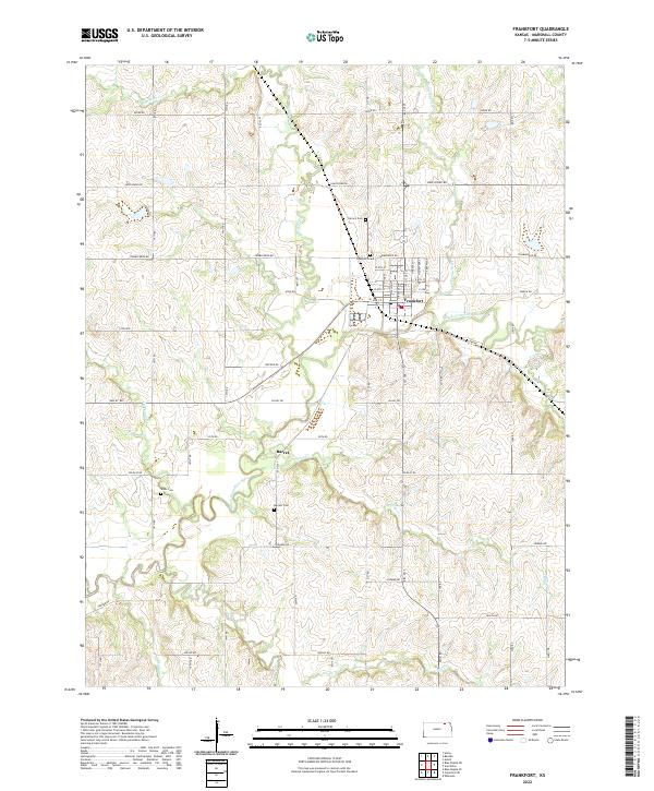
2022 Map of Frankfort
USGS Topo · Published 2022About this map
Frankfort serves as the primary hub of this Marshall County landscape, situated where the Black Vermillion River flows through the central plains of Kansas. The town's grid is clearly defined by local streets such as W 8th St and E 6th St, while the surrounding countryside is marked by a network of family-named cemeteries that provide vital clues for genealogists. The Calvary Cem and Frankfort Cem lie just north of the city center, with the Barrett Cem and Wells Cem further afield.
Find a feature on this map
41 named features on this map. Tap any name to fly to it.
Don’t see what you’re looking for? This feature index may not catch every label — zoom into the map to look around manually.
Map Details
Editions of this 2022 Frankfort Map
This is the sole edition of this map. No revisions or reprints were ever made.
Other maps of this area

1889 · Seneca
USGS Topo · 1:125,000

1889 · Marysville
USGS Topo · 1:125,000

1894 · Seneca
USGS Topo · 1:125,000

1894 · Marysville
USGS Topo · 1:125,000

1955 · Manhattan
USGS Topo · 1:250,000

1956 · Manhattan
USGS Topo · 1:250,000

1957 · Manhattan
USGS Topo · 1:250,000

1966 · Axtell
USGS Topo · 1:24,000

1966 · Home
USGS Topo · 1:24,000
1966 · Beattie
USGS Topo · 1:24,000