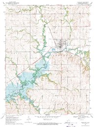
1969 Map of Frankfort
USGS Topo · Published 1971About this map
Frankfort serves as the focal point of this North Central Kansas landscape, situated at the confluence of the Union Pacific and Missouri Pacific railroads. The town's grid is dense with detail, including the Frankfort Cem and a nearby Golf Course, while the surrounding rural townships of Vermillion and Wells are marked by family-named landmarks and essential community sites like the Osborne Community Center.
Find a feature on this map
33 named features on this map. Tap any name to fly to it.
Don’t see what you’re looking for? This feature index may not catch every label — zoom into the map to look around manually.
Map Details
Editions of this 1969 Frankfort Map
This is the sole edition of this map. No revisions or reprints were ever made.
Other maps of this area

1889 · Seneca
USGS Topo · 1:125,000

1889 · Marysville
USGS Topo · 1:125,000

1894 · Seneca
USGS Topo · 1:125,000

1894 · Marysville
USGS Topo · 1:125,000

1955 · Manhattan
USGS Topo · 1:250,000

1956 · Manhattan
USGS Topo · 1:250,000

1957 · Manhattan
USGS Topo · 1:250,000

1966 · Axtell
USGS Topo · 1:24,000

1966 · Home
USGS Topo · 1:24,000
1966 · Beattie
USGS Topo · 1:24,000