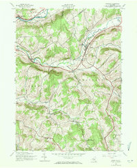
1943 Map of Franklin
USGS Topo · Published 1971About this map
New York Ontario and Western rail lines bisect this Delaware County landscape during the mid-1940s, providing a vital corridor through the hilly terrain between the Susquehanna River and the uplands. The settlement of Franklin serves as a local hub along Ouleout Creek, supported by smaller hamlets like Merrickville, Leonta, and Woodford. This survey reveals an integrated rural infrastructure of the era, where one-room schoolhouses such as School No 16 and School No 18 remained prominent landmarks for local families.
Find a feature on this map
46 named features on this map. Tap any name to fly to it.
Don’t see what you’re looking for? This feature index may not catch every label — zoom into the map to look around manually.
Map Details
Editions of this 1943 Franklin Map
4 editions found
Other maps of this area

1915 · Oneonta
USGS Topo · 1:62,500

1915 · Unadilla
USGS Topo · 1:62,500

1918 · Unadilla
USGS Topo · 1:62,500

1918 · Oneonta
USGS Topo · 1:62,500

1923 · Walton
USGS Topo · 1:48,000

1924 · Deposit
USGS Topo · 1:62,500

1925 · Walton
USGS Topo · 1:62,500

1926 · Deposit
USGS Topo · 1:62,500

1943 · Gilbertsville
USGS Topo · 1:24,000

1943 · Franklin
USGS Topo · 1:24,000