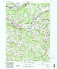
1943 Map of Franklin
USGS Topo · Published 1982About this map
Wells Bridge and Franklin sit at the heart of this Susquehanna Valley landscape, where the confluence of rail and river commerce shaped the early 20th-century economy. The Delaware and Hudson railroad tracks parallel the Susquehanna River in the northwest, while the southeastern hills are dotted with rural infrastructure like School No 16 and the Chapel Hill Sch. The creation of the East Sidney Lake reservoir along Ouleout Creek significantly altered the terrain near East Sidney, establishing the East Sidney Lake Recreation Area as a primary geographical feature. This map captures the region's transition, maintaining older identifiers like Woodford (Northfield Station) and Franklin Depot alongside newer recreational developments. Genealogists will find value in the precise locations of the Ouleout Valley Cem and Barnes Cem, which mark the long-standing family settlements in the hills surrounding Heathen Hill and Lawton Hill.
Find a feature on this map
49 named features on this map. Tap any name to fly to it.
Don’t see what you’re looking for? This feature index may not catch every label — zoom into the map to look around manually.
Map Details
Editions of this 1943 Franklin Map
4 editions found
Other maps of this area

1915 · Oneonta
USGS Topo · 1:62,500

1915 · Unadilla
USGS Topo · 1:62,500

1918 · Unadilla
USGS Topo · 1:62,500

1918 · Oneonta
USGS Topo · 1:62,500

1923 · Walton
USGS Topo · 1:48,000

1924 · Deposit
USGS Topo · 1:62,500

1925 · Walton
USGS Topo · 1:62,500

1926 · Deposit
USGS Topo · 1:62,500

1943 · Gilbertsville
USGS Topo · 1:24,000

1943 · Franklin
USGS Topo · 1:24,000