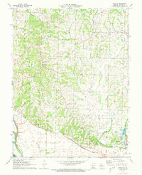
1971 Map of Franklin
USGS Topo · Published 1973About this map
The Missouri River bottomlands and the dissected uplands of Howard County dominate this early 1970s topographical record. The landscape is defined by the historic Boonslick region, where numerous family-named waterways like Tippett Branch, Carson Branch, and Casey Branch drain toward the river plain. In the south, the community of Franklin sits just north of the river, protected by an extensive Levee system that separates the cultivated flats from the rising terrain.
Find a feature on this map
29 named features on this map. Tap any name to fly to it.
Don’t see what you’re looking for? This feature index may not catch every label — zoom into the map to look around manually.
Map Details
Editions of this 1971 Franklin Map
2 editions found
Other maps of this area

1888 · Boonville
USGS Topo · 1:125,000

1890 · Glasgow
USGS Topo · 1:125,000

1947 · Glasgow
USGS Topo · 1:62,500

1947 · Jefferson City
USGS Topo · 1:250,000

1952 · Boonville
USGS Topo · 1:24,000

1952 · New Franklin
USGS Topo · 1:24,000

1953 · Moberly
USGS Topo · 1:250,000

1953 · Fayette
USGS Topo · 1:24,000

1953 · Billingsville
USGS Topo · 1:24,000

1953 · Pilot Grove North
USGS Topo · 1:24,000