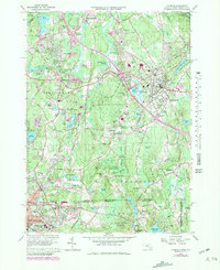
1964 Map of Franklin
USGS Topo · Published 1979About this map
The Charles River and Mine Brook define the interconnected landscape of Norfolk County as it appeared during a period of suburban expansion. Centered on the town of Franklin, this survey captures the area's mid-century character, from the academic grounds of Dean Jr College to the industrial presence of Conrail rail lines. The map reveals a transition from traditional village centers like Unionville and North Bellingham to newer residential developments such as Country View Estates and Scott Hill Acres. Significant public lands, including the sprawling Franklin State Forest, contrast with the dense grid of Woonsocket in the southwest corner. Local landmarks like the Naval Training Center and numerous religious sites, including St Marys Abbey and St Josephs Ch, provide essential points of interest for genealogists and local historians tracing the social and institutional fabric of the Massachusetts-Rhode Island borderlands.
Find a feature on this map
105 named features on this map. Tap any name to fly to it.
Don’t see what you’re looking for? This feature index may not catch every label — zoom into the map to look around manually.
Map Details
Editions of this 1964 Franklin Map
4 editions found
Other maps of this area

1886 · Blackstone
USGS Topo · 1:62,500

1887 · Franklin
USGS Topo · 1:62,500

1887 · Providence
USGS Topo · 1:62,500

1889 · Providence
USGS Topo · 1:62,500

1889 · Blackstone
USGS Topo · 1:62,500

1889 · Franklin
USGS Topo · 1:62,500

1889 · Burrillville
USGS Topo · 1:62,500

1893 · Franklin
USGS Topo · 1:62,500

1893 · Blackstone
USGS Topo · 1:62,500

1894 · Burrillville
USGS Topo · 1:62,500