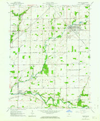
1962 Map of Frankton
USGS Topo · Published 1963About this map
Pipe Creek and the White River define the agricultural landscape of this Madison County region in the early 1960s. The town of Frankton serves as a local hub along the Pennsylvania railroad line, while smaller communities like Perkinsville and Aroma anchor the surrounding rural townships of Pipe Creek, Lafayette, and Jackson. The map reveals a high density of small family and community burial grounds, including the Mt Pleasant Cem, Prewett Cem, and Shell Cem, which provide valuable location data for genealogical research. Cultural and infrastructure details such as Camp Kikthawenund, the Township Sch, and various Gravel Pits illustrate the local economy and social structure of the era. The presence of the McClure Ditch and several pumping stations indicates the managed nature of the water table for the surrounding farmland.
Find a feature on this map
32 named features on this map. Tap any name to fly to it.
Don’t see what you’re looking for? This feature index may not catch every label — zoom into the map to look around manually.
Map Details
Editions of this 1962 Frankton Map
2 editions found
Other maps of this area

1952 · Anderson
USGS Topo · 1:24,000

1953 · Lapel
USGS Topo · 1:24,000

1953 · Riverwood
USGS Topo · 1:24,000

1953 · Muncie
USGS Topo · 1:250,000

1956 · Muncie
USGS Topo · 1:250,000

1960 · Elwood
USGS Topo · 1:24,000

1960 · Alexandria
USGS Topo · 1:24,000

1960 · Windfall
USGS Topo · 1:24,000

1960 · Anderson North
USGS Topo · 1:24,000

1961 · Anderson South
USGS Topo · 1:24,000