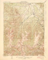
1926 Map of Fraser
USGS Topo · Published 1926About this map
The Denver and Salt Lake railroad anchors this high-elevation Colorado survey, defining the industrial and logistical character of the Fraser Valley during the mid-1920s. This period captures a critical moment in regional transportation history, marked by the presence of the Moffat Tunnel and its western terminus at West Portal. To the north, the timber and ranching economy is evident through features like the Lumber Flume and the Pole Creek School, while mining operations like the Urad Mine and Bobtail Mine dot the southern slopes.
Find a feature on this map
78 named features on this map. Tap any name to fly to it.
Don’t see what you’re looking for? This feature index may not catch every label — zoom into the map to look around manually.
Map Details
Editions of this 1926 Fraser Map
4 editions found
Other maps of this area

1903 · Georgetown
USGS Topo · 1:62,500

1905 · Central City
USGS Topo · 1:62,500

1905 · Georgetown
USGS Topo · 1:62,500

1910 · Central City
USGS Topo · 1:62,500

1912 · Central City
USGS Topo · 1:62,500

1915 · Longs Peak
USGS Topo · 1:125,000

1919 · Rocky Mountain National Park
USGS Topo · 1:125,000

1924 · Montezuma
USGS Topo · 1:62,500

1924 · Fraser
USGS Topo · 1:62,500

1926 · Fraser
USGS Topo · 1:62,500