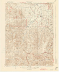
1926 Map of Fraser
USGS Topo · Published 1944About this map
The Continental Divide forms a jagged spine through this high-altitude landscape, separating the headwaters of the Williams River from the Fraser River basin. In the mid-1920s, the region was defined by massive engineering feats, most notably the Moffat Tunnel piercing the range near West Portal. This tunnel bypassed the grueling climb over the divide for the Denver and Salt Lake RR, which follows the river valley through settlements like Fraser and Tabernash.
Find a feature on this map
76 named features on this map. Tap any name to fly to it.
Don’t see what you’re looking for? This feature index may not catch every label — zoom into the map to look around manually.
Map Details
Editions of this 1926 Fraser Map
4 editions found
Other maps of this area

1903 · Georgetown
USGS Topo · 1:62,500

1905 · Central City
USGS Topo · 1:62,500

1905 · Georgetown
USGS Topo · 1:62,500

1910 · Central City
USGS Topo · 1:62,500

1912 · Central City
USGS Topo · 1:62,500

1915 · Longs Peak
USGS Topo · 1:125,000

1919 · Rocky Mountain National Park
USGS Topo · 1:125,000

1924 · Montezuma
USGS Topo · 1:62,500

1924 · Fraser
USGS Topo · 1:62,500

1926 · Fraser
USGS Topo · 1:62,500