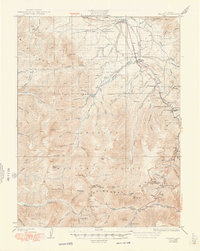
1926 Map of Fraser
USGS Topo · Published 1948About this map
Fraser and Tabernash serve as the primary valley settlements in this 1920s-era mountain landscape, shaped by the critical infrastructure of the Denver and Salt Lake railroad. The engineering marvel of the Moffat Tunnel is clearly marked at West Portal, representing a pivotal shift in transcontinental travel and local transport. The surrounding terrain of the Arapaho Range and the Continental Divide is dotted with evidence of early 20th-century industry and administration, from the Lumber Flume along St Louis Creek to the Byers Ranger Sta and Idlewild Ranger Station.
Find a feature on this map
70 named features on this map. Tap any name to fly to it.
Don’t see what you’re looking for? This feature index may not catch every label — zoom into the map to look around manually.
Map Details
Editions of this 1926 Fraser Map
4 editions found
Other maps of this area

1903 · Georgetown
USGS Topo · 1:62,500

1905 · Central City
USGS Topo · 1:62,500

1905 · Georgetown
USGS Topo · 1:62,500

1910 · Central City
USGS Topo · 1:62,500

1912 · Central City
USGS Topo · 1:62,500

1915 · Longs Peak
USGS Topo · 1:125,000

1919 · Rocky Mountain National Park
USGS Topo · 1:125,000

1924 · Montezuma
USGS Topo · 1:62,500

1924 · Fraser
USGS Topo · 1:62,500

1926 · Fraser
USGS Topo · 1:62,500